
The Scandinavian Short Cut with Stugun
Innehåll
- Introduction
- Carta Marina
- Gallea Peregrina
- Creation of the place named Stugun
- Carta Marina´s author
- Carta Marina content
- Map reading by Börje Sandén
- Carta Marina both chart and land chart
- Middle North Belt and Tröndelag
- The Bayeux tapestry represents Swedish church fabrics?
- Normandy Nordic outpost in Gaul
Introduction
The title suggests a name for a large collection of archaeological artefacts headed by Carta Marina and available documents from various parts of the last millennium covering a wide band of sites along the 63rd latitude +/- 1 deg in the northern hemisphere. Seen from the national Swedish perspective, which this story is about, this band starts from the east at the old church of Ytterlännäs inside Härnösand in the lower Ångermanälven, goes over to the Indalsälven in Bispfors, Ragunda, Stugun and cuts across Storsjön in Oviken a little south of Frösön The Sextitrean then reaches Norway in the area of Röros and covers the entire county of Sörtröndelag with Trondheim and the Nidaros metropolis in the center. Out in the North Atlantic, Orkney, the Faroe Islands, southern Iceland and the Nordic settlements with two cathedrals in southern Greenland were reached at the same latitude.
What it's about is that all the mentioned places are part of a network of Catholic churches and cathedrals that were built during a short period in the middle of the 12th century when baptized Nordic Viking kings, merchants and educated bishops from various clans grew so strong that the papacy could, shall we say bless, that the former Danish archdiocese for the whole of the Nordic countries could now be divided into independent Norwegian and Swedish archdiocese, which each wanted to communicate on their own or hired safe keels outside the waters of the Danes with the traffic between Rome and the band of the newly added churches. The main actor and first was the incomparably largest and wealthiest archdiocese of Nidaros, based in Tröndelag county, of which Jämtland-Härjedalen was in practice an ethnic part right up until the founding of the Union in Moss in 1814.
The breakaway of the Swedes from the Danish empire came a decade later than the Norwegian one, and was also slowed down by the fact that the Swedes' trade on their own ships was blocked in the Bothnian Sea north of Gotland by a new independent European trade actor, the Hanseatic League, which monopolized the Danish trade along all the coasts of Scandinavia from approximately Blekinge- Ven and up to the city of Bergen in Norway. The solution to that problem was subsequently mapped out by the East Goth priest and later bishop Olaus Magnus with the printing and publication in 1539 of the Carta Marina chart, which precisely tries to describe the power and liberation of the Nordic peoples from the 12th century onwards to join the Catholic community .
Carta Marina
The amazing thing is that the entire Swedish medieval history presented in Carta Marina is a neglected, obviously misunderstood and seriously underestimated document in Swedish and international historical research and an almost contemporary archaeological source, which can explain repressed parts of the Nordic development within high medieval Nordic society , which I will try to develop here in a seemingly sourced and scientific context but in simple everyday language.
The last bit, which connected the Nordic cathedrals of the sixty-third latitude with those of southern Europe, is not visible on the Carta Marina but can most simply be described as the connections between the early churches in Iceland that crossed Scotland down through the Irish Sea and the Viking stronghold on the Isle of Man down to the Norman area of Gaul.
Gallea Peregrina
The traveling summer time of the Archdiocese of Uppsala and Nidaros with oars and sails on self-controlled keels was described in the fifteenth century by Olaus Magnus as Gallea Peregrina' which reached Normandy and thus Gaul at the outlet of the river Seine in the English Channel. Here, the Norwegian Viking Roland or Rollo had already at the end of 700 obtained the Department of Normandy as a fief from Charlemagne in exchange for Rollo's baptism and promising to stop all new Viking raids against Paris in the future. The Norse merchant ships that were used at this time were equipped with square sails, a full set of oars and a simple cabin for VIP passengers and fragile luggage. These ships with oars and sails could be kept running on the open sea day and night in the northern latitudes during the best summer months regardless of wind direction, comparable to today's motor-driven shipping. The same shipping system was of course also responsibel for the possibility to extend catholic community to southwest of Greenland, and before that the Viking Eric the Read and his son Leif Eriksson's expeditions to New Foundland could be done. 
The fuel for the biological muscle engine that propelled the rowing ships must also, according to the everyday logic depicted in the many Edda sagas, have been the boar Särimner's fat-rich food products consumed every evening. Using the same logic that explains the camelids' functioning desert migrations, pork products can supply the body's chemical needs for both energy and water for much longer periods of time than today's sugar-doped and water-impregnating biological engines can provide, where the action time between each sip and bite of water and energy bars rarely exceeds 1 hour.
Creation of the place named Stugun
Stugun's place in history is connected with conflicts and contradictions that arose approximately one hundred years after the start of the Nordic archdiocese, i.e. around the year 1250. The main argument that the locked situation for Sweden's archdiocese had arisen was that the German Hansa had its rapid development in 1200- century and introduced trade monopolies in the entire Baltic Sea area south of Visby's latitude, and this came in practice to stretch around the current Swedish coast and also follow southern Norway up to ports in the Bergen area. This meant that the Hanseatic merchants impeded Swedish trade and shipping, as well as controlling the Danish archdiocese of Lund and its communications down through Germany and across the North Sea to the Anglo-Saxon coasts of Holland and England. The first in modern times who, as far as I can see, has started the mapping of the Stugun history was my grandfather A J Hansson from Kyrkås, Jämtland with the study in the Stugu Book from 1927 about Gjurd Bodakarl's charter and the meaning of and intentions for the establishment of the soul cabin with hostel (with AJH's own words a "traveler's shelter") in Stugun. After a review of all medieval letters in the Swedish Diplomatarium, AJH sorted out all the letters that dealt with the various affairs of the church and monasteries, where he also saw a connection between the Alsnö statute and the special interest of the Uppsala Arcbishops in the unique letters of reference to only the patronage in Stugun.
Neither in A J Hansson's nor in my current collection of historical references from the Catholic Middle Ages is there any evidence that so-called pilgrimages of "common people" from the old Swabian kingdom to Saint Olav in Nidaros had taken place or even been a desirable and possible goal for anyone other than St. Bridget, who we know had at least passed through Nidaros on her way out into the world.
A short summary of Stuguboken in English comes inStugun's early history.
Carta Marina´s author
The people who were responsible for and carried out the collaboration behind the creation of this great work were two priest-educated brothers Olof and Johan Månsson, born in 1490 and 1488 in Skänninge and "primary schooled" in Linköping. They advanced in the 1520s to dean of Strängnäs cathedral or to archbishop in Uppsala's archdiocese. Both had received their Catholic educations in Rostock Germany, and they now called themselves in the 1520s Olaus and Johannes Magnus and both initially worked for their church offices in close contact and agreement with King Gustav Wasa during his first years of reign and also performed diplomatic missions down in Europe on behalf of the king.
Both Olaus and Johannes were, as patriots, good writers and historically interested in their Nordic homeland and its population. The brothers were also well aware that the three Scandinavian archdiocese had arisen and developed under conditions which, for somewhat obscure reasons, had richer harvests and larger populations than prevailed during the brothers' lifetimes. But one must also remember when assessing their work that the publications took place in close connection with the papal curia in Rome, in the middle of the 16th century, and were addressed to recipients in the Catholic clergy, who knew very well the Nordic ice age that now had ruled and influenced cultural life and society for several hundred years in the north and which was also shown on the Cartan and in the scriptures.
Middle Northland was given a prominent place in their lives due to the fact that in the years 1518 – 19 Olaus had had a papal mission to travel around to the parishes here and sell Catholic indulgences that could give the buyers forgiveness of sins and provide the Pope in Rome with funds for the reconstruction of St. Peter's Cathedral. Kurian's interest in taxation in this very corner and outermost outpost, considered by national Swedish secular and ecclesiastical leaders, may well also give rise to reflections on the area's economic importance during earlier history.
To be sure, the Swedish de facto successor to Archbishop Johannes Magnus, i.e. King Gustaf Wasa, had also at the time of Cartan's publication legislated the Reformation in the Kingdom of Sweden (SCANDIA on the big map) and started a close collaboration with the "The Dean of Jämtland" Erik Andersson in Oviken in order to re-create and divest the large Jämtland church business on "dispensable assets" for the benefit of the emerging military needs of the Swedish kingdom.
The exile to Rome
Their collaboration and friendship with Gustav Wasa soon began to sour as the king listened more and more to Lutheran advisors, and in 1527 the king introduced the Lutheran Reformation in Sweden, which forced the Catholic Magnus brothers to go into exile in Europe for the rest of their lives and finally staying in Italy for the sake of his Catholic views. They had become heretics in the Protestant judgments. Henceforth, for their livelihood, both devoted themselves entirely to the writing of their famous historical works, and Olaus Magnus worked for the first twelve years of his stay abroad with Carta Marina, as preparation for his literary work "Historia om de Nordiska folken" in four thick volumes.
Carta Marina content
In summary, it can be said that their descriptions of the greatness and social development activities of the Nordic peoples were about the memories that remained after the high medieval society that had been built up from Catholic Christianity in the 11th century and up to the catastrophic bubonic plague that occurred in 1350.
In my document search, it is the map's geographical and architectural descriptions of the pre-reformation or Catholic infrastructures that have been most interesting. I would like to try to put this in relation to the changes that were affected by the combination of dieback, the climate deterioration that culminated in the "little ice age" when the map was produced, Gustav 1 Wasa's Lutheran reformation at the same time and not least the constant war preparedness and the tug of war over Jämtland between Swedish and Norwegian-Danish armies, which lasted from the Christianization around the 11th century and right up to the 1814 union treaty with Norway.
The first printing of the map, which Olaus Magnus himself ordered in 1539, was made in Rome, and it is very rich in detailed information in the images from places that OM himself reconnoitered, while other parts of the Nordic region are here and there filled with depictions of folk life and symbolic place markings.
O M's written "History of the Nordic Peoples" was published in Latin and contains notes on his personal experiences. Even the text on the printed Carta is in Latin, which causes problems when he has to spell the names of local places with a limited Latin alphabet.
Map reading by Börje Sandén
>The ancient conception of geography is reflected in the first sketchy maps. Regarding the comparison with maps, the starting point is the map found in Olaus Magnus's big book on the history of the Nordic peoples from the year 1567. The original task of maps was to show the sea route to different places - in this case in the Nordic countries and the nearest part of Russia. It is seen that rivers and lakes are connected in a network of connections. Between the rivers and the lakes it was naturally the land route that applied.
The map in Olaus Magnus' book on the history of the Nordic peoples in 1567
The first Nordic map/sketch of importance - and which became widely known - is the one found as a leaflet in Olaus Magnus's large book on the history of the Nordic peoples. 
Comment Jan: It was drawn carelessly for some reason and contains some errors. Bottnia Occidentalis/Västerbotten must be moved up a step past the lake above which must be the Lacus Uma Träsk/ie Flata/Ström's floodplain in the present day (explanation below). Beyond the Uma swamp lies Storsjön in Jämtland and between the lakes the area Angermania/Ångermanland should enter, and south of Storsjön should be Iemphtia/Jämtland and below that Middelpadia according to the large map Carta Marina.
Börje: The map is based on several basic methodical and unwritten laws, which we must first become aware of in order to be able to read the map image correctly. Most striking is perhaps the narrow and straight shape of the Bothnian Sea and the Gulf of Bothnia in the middle of the map. It was practical to put the boundary between the two blocks of wood that the woodcarver has used here. Despite the "wrong" direction, a traveler will not miss Haparanda, if that is where he is going. Also notice that the oldest maps have no north arrow. You immediately realize why when you see how to draw the Gulf of Finland. When the map was made in the middle of the 16th century, the Swedes had at least a thousand years of experience that the Gulf of Finland ran in a west-east direction, and of course they knew that Finland was not long and narrow. It was also known that the route continued east into Russia to Lake Ladoga, and there changed direction and went straight south down to Novgorod. Therefore, notice that the route from Ladoga on the map goes south, just like in reality. The weather lines thus vary on one and the same map - and it's actually not just on this map that's the case.
But it is important to realize that maps of this kind are not made after any planned reconnaissance. The maps are a desktop product based on primarily written experience over hundreds of years. That is the explanation for why the Barents map is surprisingly well drawn. The exception is the Mälar area. There are two circumstances that dictated the mapping. The main task of the map is to show the sea routes - at sea! The map is aimed at seafaring traders and the ambition is to show the settlements along the coasts. The other important message that the map gives us is that Uppsala is by the sea. All available information for the cartographer down in Europe at the end of the 16th century was that you reach Uppsala without transshipment to smaller ships. That there has been - and is - a rise in land in the Nordic region, one could not imagine - but they had observed a significant, inexplicable decrease in water. Olof Rudbeck stated in the 17th century that one could no longer sail up the Fyrisån as far as a man of old age before. The city was, after all, by the sea according to all tradition. Mälaren closest to Stockholm was, according to the cartographer, still perceived as part of the sea, despite the fact that there had been some countercurrent at Stockholm in the early 14th century, especially during the spring flood.
Carta Marina both chart and land chart
Here I first show a combined overview of the nine square printing blocks that cover a very large geographic area in the Nordics, and which became the first map that had the main features of all coastlines in the area determined in position.

Middle North Belt and Tröndelag
is the part of the full map that I have named
Scandinavian short cut with the soul cabin
aiming at the description of the cartographer's depicted structures in the geographical distance between the coasts of the inland crossing. 
Carta Marina's western side begins in the north with the Trondhjemsfjord's innermost harbors at STEK/Steikjer and LESVNGER/Levanger and ends in the south with the important outport at cape STAD, controlled by the domestic Norwegian trade, about 30 land miles south of the infjord ports at Nidaros (Nidelva outlet/ us). In the Norwegian hinterland is GOLDAL/Gauldalen, which leads up towards Trondheim. At the bottom, a man stands and probes the water depth at the important port of Stad, which is considered the main port for the traffic from Northern Norway and Tröndelag, which is directed towards Shetland - Orkney - Scotland and towards the Faroe Islands - Iceland - Greenland. Overview map and travel times can be found further down the page.
The carton starts on the Swedish bottom bay coast at the High Coast in NORDMALUNG/Nordmaling and SCVLA MONS/Skuleberget, then a short land route to NETRA/Nätra, TORSAKER/Torsåker, SOLETA/Sollefteå at Ångermanälven before taking the road over Graninge to FORS and RAGVND at Storån/Indalsälven /THE ELEVEN. From here, follow the Stuguleden in Jämtland across STVVA - VESTERHUS with Kungsgården/DOMUS REGIA SVDA/Sunne to VNDERAKER/Undersåker. In the south, the map reaches down to BOLLANES/Bollnäs and SODERALA/Söderala, and a little below these with obscured text SKOKIRKIA/Skogs kyrka, where one of the old art textiles was found that is contemporary with the Kyrkåstäcket. If you go straight east from SKOKIRKIA, you reach on the map first ORSA and then LACVS SILIEN/Siljan. The Österdalälven from here crosses Älvdalen – Idre where you have the large lake Femunden quite close on the Norwegian side. At Femunden you almost reach Röros and the trail through GOLDAL in the direction of Nidaros. South along the coast, the map reaches down to Gnarp and Rogsta and the lake system Dellen, which lies north of the modern Hudiksvall. Ljusnan's valley comes up at COGERBELA/Kårböle, past LANGA/Långå and across the border at Fjällnäs, you are also close to the old Norwegian town and mining site Röros. Jamtli museum has a video by historian Olov Holm and archaeologist Björn Olofsson about old churches, which well illustrates both Anna Elmen Berg's medieval map of abandoned churches and Carta Marina's segment above of churches in the area. The video https://www.youtube.com/watch?v=S3xGG3DUelk shows analyzes of the archeological artifacts false ceiling boards from the year 1150 preserved in Kyrkå's old stone church, which directly replaced the first, now 400-year-old wooden church. The stone church was built around the year 1540. As the icing on the cake, we can now also dust off and add the pictorial symbolism from sea shipping with the 11th century’s rowing ship which is depicted centrally on the artifact from the wooden church which I here call the Kyrkås antependiet with two ship images on the textile.


 Two sharp photos were taken at a museum in Stockholm before all the parts were repackaged and in 2015 were collected for a rather anonymous presentation at the home ground museum Jamtli in Östersund, where I tried to take the third photo. In any case, you can see a large clear and impressive rowing ship with sails, which is placed in the center of picture 1.
Then we have the cut-off fragment from the lower edge of the antependium, where until now everyone has asked themselves what the four-legged animal represents, which probably represents all the horses involved, which also appear in pictures in the history of the Nordic peoples and not least in very detailed and dramatic representations on the Bayeux Tapestry. No one has talked about the clear rowing ship with torned sails that comes in just below the animal. The symbolism of ocean-going ships on this church textile must reasonably be placed in relation to the fact that this church site is right in the middle between the east and west coasts of the Carta, and also on a watershed 400 meters above sea level, that it may be time to remind of the seafaring heading in both directions here in the middle of Scandinavia's interior.


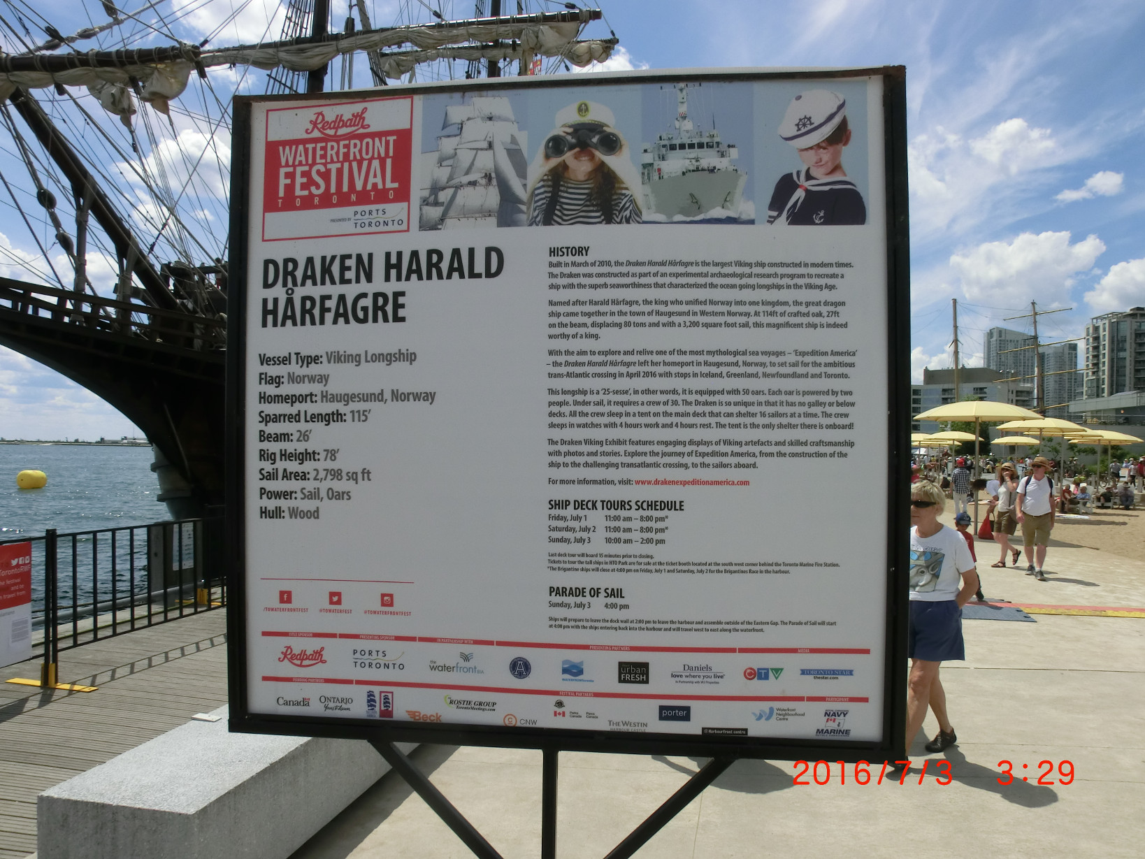
If anyone doubts whether this ancient shipping was possible, I can now show that during a tourist visit to the Toronto harbor in the summer of 2016, I had an unplanned encounter with a modern copy of the old dragon boats, which had just sailed across the North Atlantic with 30 men crew from the construction site in Haugesund Norway, across Iceland, Greenland, New Foundland, through the St. Lawrence River to Toronto, located on Lake Ontario - the northernmost of the five "The Great Lakes of North America". The first image shows one of Carta Marina's perceptions of what the boat looked like, such as the one Olaf Haraldsson/St Olaf could have used when he was young visiting relatives in Rouen, Normandy in what was then the country of Gaul around the year 1000.
Harald Hårfagre shows the ship's data, which briefly states length about 30 m, displacement 80 tons, "25 sesse" means 25 oars on each side=50 oars - each oar has two men - full manning requires a crew of 100 men. On this trip, the ship only went to sea with sails and then had a crew of 30 men. Carta Marina's depicted ship for Catholics traveling by merchant ship between Norway and Gaul may have roughly equivalent data but have a different keel design with low fore and aft sterns. Hårfagre's dragon masts here were intended for warships.
An important difference to the cartography on the fold-out sheet with Börje Sandén's descriptions is that the waterways navigable by boats were shown there as schematic lines, while the detailed large Carta Marina could only show the largest lakes as figureless symbols and leave the rest of the running waters to the imagination.
The large lake-filled areas in northern Jämtland and Lapland were called swamps, where, for example, the busy area of Ströms vattudal was named Uma träsk after one of the larger entrances from the Umeälven river and the gateway from Jämtland is called ASUND, where A stands for Å=Ström, so the place Strömsund. The following excerpt covers the entire areas for the trails along the Indalsälven and Ljungan. Some important lakes have been given names such as Lacvs Meler/Mälaren and LACVS Vener/Vänern, while for example Storsjön in Jämtland is nameless, possibly because Olaus M had difficulty deciding whether it was TRESK or a single LACVS.
Olaus Magnus also marks the locality SVAKBV/Sveg and LACVS SVAKA/Svegsjön, which is flowed by the FLV LVSEN/Ljusnan as an important waterway during some high medieval period, which probably preceded Stugun's start, i.e. before 1250, which also gives the Överhogdal tapestry a natural place and connection as early medieval road sign for part of the Scandinavian thoroughfare from the Uppsala Diocese to the priestly colleges in Gaul and south of it.
The Bayeux tapestry represents Swedish church fabrics?
Here we can also suspect a connection to Olav Haraldsson's activities. His nephew (after Harald Hårdråde) Olav Kyrre (according to Alf Henriksson's chronology) participated in the Battle of Hastings in 1066, survived and should have been well aware of the Bayeux Tapestry's creation and also an interest in copy it for use as road signs in suitable Scandinavian churches.
Normandy Nordic outpost in Gaul
The protection agreement between Rollo's fief Normandy and the city of Paris worked for the good of everyone and led a few generations later to the twelve-year-old Viking Olaf Haraldsson, son of a petty king in Vestfold in South of Norway, accompanying a ship that from the year 1007 began raiding the Baltic Sea in order to some years go to Normandy on the lower course of the Seine. Here Olaf remained for a few years with Christian Rollo descendants, took part in campaigns against England, was educated at the cathedral school in Roen and was baptized before he returned to Vestfold in 1015 and began to claim the Norwegian royal crown after his father Harald Grenske and other rulers. Olav conquered power and rather harshly ruled a Christian Norway from present-day Sarpsborg until the year 1028 when he lost courage to the Danish Cnut the Great, who now also conquered England. Olav Haraldsson's path to sainthood could perhaps have followed the historical traces of the struggle for the English throne as described above?
In 2024 have historians and archeology in Norway started questioning the Stiklastad 1032 warfield and happenings so maybe is this part of pilgrimages a saga from later centuries. Truth is that Olaus Magnus during the very last medieval years in Scandinavia describe and followed the traces of summertime travelers from his home land in central parts of Sweden, who were forced to cross the harsh mountains of Jämtland in order to comunicate with his exile in Rome.